
Omamap
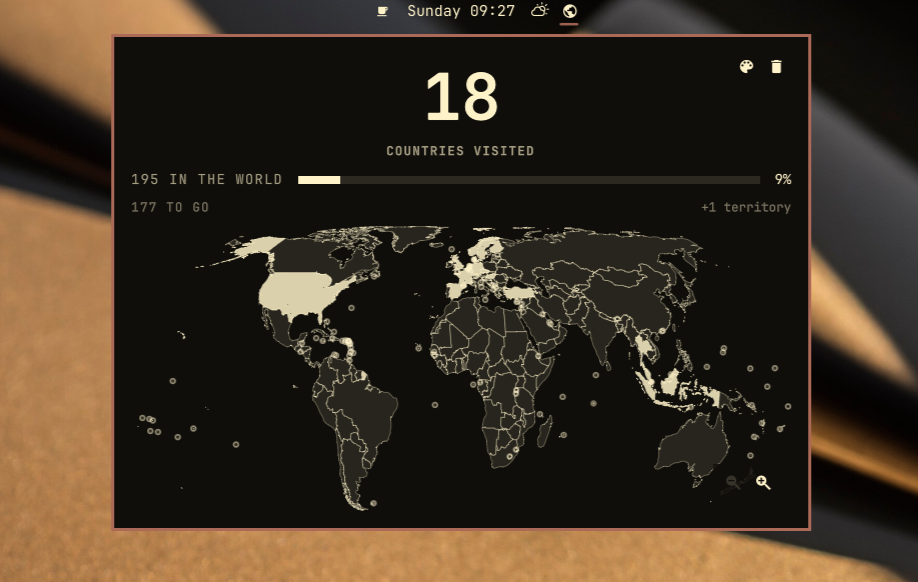
A world map that lives in your Omarchy bar. Click a country you have been to and it fills in; the number above the map goes up. Click it again and it does not.
Install
omarchy plugin add https://github.com/ejuro/omamap.git --enable
Use
- Left-click the globe in the bar for the map.
- Left-click a country to mark it visited, left-click again to clear it.
- Scroll to zoom — the map zooms about the pointer, so the place you are looking at stays under the cursor. Drag to pan.
- Or the controls in the bottom-right of the map: out, in, back to the
whole world. Or the keyboard:
+-0, arrows pan,Esccloses. - Hovering a country names it. Territories name who administers them, so Greenland reads Greenland · Denmark.
- in the top-right picks the colour the map is filled in, from your theme's own
palette, minus anything that would vanish against the panel. Changing themes
puts it back to matching the new one.
copens it. - beside it clears the map, after asking.
xdoes the same. - The widget's Bar label setting puts the count or the percentage next to the globe in the bar.
The count
195 is the 193 UN member states plus the two permanent observers, the Holy See and Palestine.
Territories and dependencies — Greenland, Puerto Rico, Hong Kong, Taiwan — are on the map and can be filled in, because they are real places you can have been to. They are counted on their own line, so the big number keeps meaning what it says.
State
${XDG_STATE_HOME:-~/.local/state}/omamap/state.json
A sorted list of ISO 3166-1 alpha-3 codes, and the map colour if you picked one. Readable, diffable, and yours to back up:
{
  "version": 1,
  "visited": ["DNK", "ISL", "NOR", "SWE"]
}
How the map was made
The projection is Equal Earth, which is equal-area: a country's size on screen is proportional to its size on Earth. On a Mercator map Greenland looks bigger than Africa, which is a strange thing to stare at while counting how much of the world you have seen.
The borders are Natural Earth's 1:50m country polygons, public domain, taken from
nvkelso/natural-earth-vector at
tag v5.1.2 — upstream itself, not a repackaging. That GeoJSON is committed to
this repository, with its SHA-256, under tools/source/.
tools/build-data.mjs verifies the checksum, projects the coordinates, simplifies
them to the precision the deepest zoom can actually show, and writes
WorldData.js. It then refuses to write unless the result still holds up: all 195
countries present, total land area within 2% of 134 million km², the nine largest
countries coming out as the nine largest countries, and a handful of countries
spanning four orders of magnitude landing within 12% of their published areas.
Some thirty countries come out too small to click at world zoom, and three — Vatican City, Monaco and Tuvalu — are smaller than a single pixel at any zoom the map goes to. Those draw as dots, which turn back into real outlines as you zoom past them, so every one of the 195 is clickable without zooming at all.
Dependencies
None. No package.json, no npm install, no libraries. The GeoJSON walk, the
Equal Earth projection, the Visvalingam simplifier, the point-in-polygon hit
testing, the contrast filter behind the colour picker and the tests are all code
in this repository. The one file that came from anywhere else is that Natural
Earth GeoJSON, which is committed, checksummed, and only ever handed to
JSON.parse.
At runtime it needs Omarchy and nothing else. No network access and no
privileged commands — the borders ship inside the plugin, so it never opens a
socket. It writes one file, its own state.json, and reads two: your theme's
colors.toml and theme.name, so the map can match the theme and follow it when
you switch.
Remove
omarchy plugin remove io.github.ejuro.omamap
rm -rf ${XDG_STATE_HOME:-~/.local/state}/omamap
License
MIT. Map data is public domain, per Natural Earth's terms of use.