
Globe Guesser
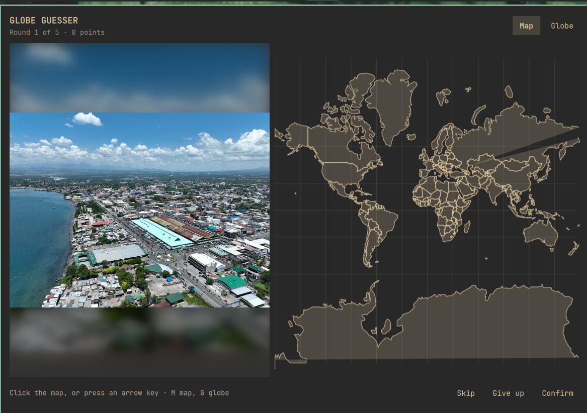
A photograph, somewhere on Earth. Click the map — or spin the globe — to say where you think it was taken.
Five rounds, 5,000 points each, scored on how close you got. Your best run is kept.
What it does
- A real photo of a real place. Each round draws a city from a bundled list of the 1,000 largest in the world, then asks Wikipedia which articles sit near it and takes their lead images. An article with a coordinate is almost by definition a place — a station, a bridge, a district, a cathedral — and its lead image is a photograph an editor chose to show what that place looks like. The answer is the article's own recorded position, not the city centre.
- Two ways to guess. A flat world map you can pan and zoom, or a globe you can spin. Both are drawn from bundled Natural Earth outlines, so the whole game works with no network, no account and no key. Add your own free CARTO key and the map upgrades to real OpenStreetMap tiles you can zoom to street level — see Map detail.
- Playable without a mouse. Arrow keys (or
hjkl) place and nudge the pin,Enterconfirms,MandGswitch between map and globe,Esccloses. - Attribution shown. Commons photographs are almost all CC-licensed. The photographer and the licence appear with the answer, because the licence is only honoured if they travel with the picture.
Use
| Control | What it does |
|---|---|
| Click the map or globe | Place your guess |
| Drag | Pan the map, or spin the globe |
| Scroll | Zoom, centred on the pointer — all the way to street level with a CARTO key set, to country shapes without one |
Arrow keys / hjkl |
Place the pin, then nudge it — finer the further you are zoomed in |
M / G |
Switch to the map / the globe |
Enter |
Confirm the guess, then move to the next round |
Esc |
Close the panel — a game in progress is still there when you reopen it |
| Skip | Draw a different photo without scoring the round |
Install
omarchy plugin add https://github.com/kairos-tech-oh/omarchy-globe-guesser.git --enable
Then add Globe Guesser to your bar from the Omarchy settings UI, under Fun.
That is the whole install — the game plays with no key, no account and no network. Optionally, add a free CARTO key for street-level map detail: see Adding a key.
The shell normally picks the plugin up immediately. If the widget does not appear, restart it once:
omarchy restart shell
Update
omarchy plugin update kairos.globe-guesser --yes
Remove
omarchy plugin remove kairos.globe-guesser --yes
If the plugin directory was placed at ~/.config/omarchy/plugins/kairos.globe-guesser
by hand rather than by omarchy plugin add, remove that directory and restart
the shell instead:
rm -rf ~/.config/omarchy/plugins/kairos.globe-guesser
omarchy restart shell
State left behind. Two things, and omarchy plugin remove deletes neither,
so remove them by hand if you want nothing left:
rm -f  ~/.local/state/omarchy/globe-guesser-state.json   # best score, games played
rm -rf "${XDG_RUNTIME_DIR:-/run/user/$(id -u)}/omarchy-globe-guesser"
rm -rf ~/.cache/omarchy-globe-guesser                     # only if XDG_RUNTIME_DIR was unavailable
The first is a 34-byte JSON file holding your best score and how many games you
have finished. The second is the download cache: at most three photographs, plus
a tiles/ directory of at most 256 map tiles if you set a CARTO key. Both live in
a directory that is cleared at logout anyway, because it is on tmpfs.
Your settings live in the shell's own shell.json alongside every other widget's,
and are removed with the widget when you delete it from your bar. That includes
your CARTO key, so removing the widget removes the key with it. To clear the key
without removing the widget:
omarchy bar set kairos.globe-guesser cartoApiKey ""
Settings
Under Fun in the Omarchy settings UI. Any of them can also be set from a terminal, which takes effect immediately:
omarchy bar set kairos.globe-guesser <setting> <value>
The <setting> is the key name in the table below: difficulty,
roundsPerGame, defaultView, searchRadiusKm, cartoApiKey.
| Setting | Options | Default | What it changes |
|---|---|---|---|
| Difficulty | easy / normal / hard | normal | Which cities a round can come from: the 150 largest, the 500 largest, or all 1,000 |
| Rounds per game | 3–10 | 5 | How many photos make up one game |
| Starting view | map / globe | map | Which surface a round opens on. You can switch mid-round either way |
| Photo radius (km) | 1–10 | 10 | How far from a city centre a place may be. 10 km is both the default and MediaWiki's hard ceiling for a geosearch, so this only ever narrows the search |
CARTO basemap key (cartoApiKey) |
text | (empty) | Optional. Empty means the map is drawn from bundled outlines and no tile is ever requested. Set it for street-level detail — see Adding a key |
Network use
Three small requests per round, all anonymous, none needing an API key or an account. Out of the box the plugin makes no map-tile request at all — the map is drawn from bundled offline outlines. Street-level tiles are opt-in and need a key of your own; see Map detail below.
| Service | What for | Published limit | What this plugin does |
|---|---|---|---|
en.wikipedia.org/w/api.php |
One geosearch query listing articles near a city with their coordinates and lead images |
No hard anonymous limit; the user-agent policy requires a descriptive User-Agent | One identifying User-Agent, one query per round, never more than one request per second. Measured 17–30 KB per reply |
upload.wikimedia.org |
Downloads the one chosen photograph | — | One download per round, capped at 6 MB, no redirects followed |
commons.wikimedia.org/w/api.php |
The photographer and licence for that one file, so the credit can be shown | as above | One request per round, at reveal, off the path that decides how fast the photo appears. Measured 361 bytes |
basemaps.cartocdn.com |
OpenStreetMap map tiles, while the map is on screen | Requires an API key since August 2026; free to 5M tiles/month | Only if you set a key. With none, nothing is requested. At most 64 tiles at a time, ~18 for a typical pane, six transfers in flight. Each capped at 256 KiB and refused unless it is a PNG of at most 512×512. Cached on disk and by URL, so panning back over ground already seen costs nothing |
Map detail and the CARTO key
The game is fully playable with no key and no account. The map and the globe are drawn from bundled Natural Earth outlines — coastlines, borders, and the shapes you need to place a city — and that is the default.
What a key buys you is detail: real OpenStreetMap tiles you can zoom down to street level, which makes a hard round much more guessable.
In August 2026 CARTO began requiring an API key for their raster basemaps and
stamping an API KEY REQUIRED watermark across every unauthenticated tile. The
request still succeeds and the tile is still a valid image, so this is not a
failure the plugin can detect and route around — it just comes back defaced.
Rather than ship a watermarked map, or embed a key of ours that would be a shared
secret in a public repository and our quota to exhaust, the key is yours:
Adding a key
1. Get one. Free at carto.com/basemaps/apikey, no card. Fair use is 5 million tiles a month — this plugin fetches about 18 for a new map view, and never re-fetches a tile it already has.
2. Set it.
omarchy bar set kairos.globe-guesser cartoApiKey "your_carto_key"
It takes effect immediately. No restart, no reopening the panel — open the map and the tiles are there.
The setting is named CARTO basemap key wherever Omarchy shows widget settings.
Changing or removing a key
Same command with the new value:
omarchy bar set kairos.globe-guesser cartoApiKey "your_new_key"
To remove it and go back to the bundled outlines, set it to an empty string:
omarchy bar set kairos.globe-guesser cartoApiKey ""
Clearing it takes effect immediately too: the tiles already on screen are dropped and the outlines come back, because a tile fetched under a key you have withdrawn is not one this plugin should keep showing.
Both commands edit the plugin's entry in ~/.config/omarchy/shell.json, so you can
also edit that file directly if you prefer — the key lives on the widget's entry
as "cartoApiKey".
Checking it worked
Zoom in. Streets and place names mean the key is good.
If the map comes back with API KEY REQUIRED written across it, the key is wrong.
CARTO answers a bad key with exactly the same watermarked tile it sends for no key
at all — byte for byte — so the plugin cannot tell those two cases apart and does
not pretend to. Re-run the set command with the correct key.
If the map shows plain country outlines and no watermark, no key is set and nothing is being requested. That is the default and it is not an error.
Why CARTO and not tile.openstreetmap.org. The OSM Foundation's
tile usage policy forbids
distributing an application that draws on their servers — they are donated
infrastructure for the map's own website, not a free CDN. The same rules out
maps.wikimedia.org, whose policy limits it to sites hosted by the Wikimedia
Foundation or its affiliates. CARTO renders the same OpenStreetMap data, and the
map shows the attribution their terms require.
Every response is capped at the producer before the shell can hold it: 256 KiB for the article query, 32 KiB for the credit, 6 MB for the photograph. Nothing else is contacted, ever. The map, the globe, the scoring and the "12 km from Kyoto" line are all computed from bundled data.
Nothing is loaded into an Image straight off the network — not the
photographs, and, since the decode ceiling was tightened, not the map tiles
either. Both are downloaded first, under a byte ceiling at the producer, and both
have their image header read and checked before anything decodes them.
The reason the header check exists and a size cap is not enough: a PNG stores its
pixel count in the header and its pixels compressed, so the two numbers are
unrelated. A 61 KiB file can declare 8000×8000. Qt's sourceSize does not save
you there — it scales during load for JPEG only, and for any other format it
loads the source at full size and scales afterwards, so the peak is already paid.
Measured on Qt 6.11.1, loading such a file into an Image with sourceSize set
to 320×240 peaked at 439.6 MiB against a 75.2 MiB baseline, inside the
long-lived shell process. So a photograph is refused above 8 megapixels and a
tile above 512×512, on the dimensions their headers declare, before a decoder
ever sees the bytes.
One extra request happens when you open the panel while no game is running: the first round is fetched while you are still looking at the start screen, so pressing Start shows a photograph rather than a spinner. Opening the game is taken as intending to play; merely having the widget on your bar is not, and nothing is fetched at login.
Turn the network off mid-game and the photograph fails with a readable message and a Try another button. If you had tiles, the map notices they are not arriving and falls back to the bundled outlines, so you can still place a guess — with country shapes instead of streets. Without a key it was already drawing those outlines, so the map does not change at all.
Where the map comes from
The detailed map is OpenStreetMap data, rendered by CARTO, fetched as tiles while you play. The fallback map and the globe come from bundled data:
data/WorldOutline.js and data/Places.js are generated from
Natural Earth (public domain), pinned to an
exact upstream commit. data/PROVENANCE.md records the commit, the SHA-256 of
every input and output, and how to reproduce them:
tools/build-world.py --check
Development
tools/run-checks.sh
Runs three things: that both data files rebuild byte-for-byte from the pinned upstream commit, that the maths and the sanitisers behave under Node, and that they behave under Qt's V4 engine — which is the engine omarchy-shell actually uses, and is not Node.
Files
| File | What it is |
|---|---|
BarWidget.qml |
The bar slot and the click target that opens the panel |
Panel.qml |
The game: state machine, the two network calls, scoring, persistence |
GlobeMap.qml |
The guessing surface — tiles, outline canvas, markers, pan/zoom/spin |
TileLayer.qml |
The OpenStreetMap tile grid — fetching tiles under a byte and dimension ceiling, caching them, and noticing when they cannot be reached |
PhotoPane.qml |
The photograph, its loading and error states, and its attribution |
GeoMath.js |
Projections and their inverses, great-circle distance, the score curve |
Sanitise.js |
Everything that crosses into or out of the plugin as text |
data/ |
Generated country outlines and city list, with provenance |
tools/ |
The generator and the check suite |
Dependencies
curl, head, od, mktemp, timeout, find — all present on any Omarchy
install. python3 and node are needed only to regenerate the data or run the
checks, never to play.
Attribution
Photographs are the lead images of Wikipedia articles, served by Wikimedia Commons, and remain under their own licences, shown with each answer.
Map tiles are © OpenStreetMap contributors, © CARTO, shown on the map itself. OpenStreetMap data is licensed under the ODbL.
The bundled fallback map and the city list are from Natural Earth, public domain.
Licence
MIT. See LICENSE.