
Omahub
← All plugins
S

Satellite Radar

by SeanGSR

Track satellites above your location or across the globe from the Omarchy bar.

Security review

Review recommended · 1 finding

Deterministic scan — not a security guarantee

Medium
Risk level
Medium
Analyzed commit
918ba59
Scanned
1 month ago
  • medium external_hosts locate:24

    Downloads or connects to an external HTTP(S) host.

    curl -fsS --max-time 8 https://get.geojs.io/v1/ip/geo.json 2>/dev/null | jq -c '

Automated analysis only — not a security guarantee.

AI advisory review

No obvious issues detected

Language-model assessment · ~deepseek/deepseek-v4-flash-latest — advisory only

Low
AI risk level
Low
Recommendation
install
Model
~deepseek/deepseek-v4-flash-latest
Analyzed commit
918ba59
Reviewed
1 month ago

The plugin makes expected network calls to fetch satellite orbital data, map tiles, geolocation, and geocoding services. No malicious behavior, obfuscation, or destructive commands were found. The external host flagged by the scan is a standard IP geolocation service used for automatic location detection.

  • Network calls to external services (CelesTrak, CARTO/OpenStreetMap, Open-Meteo, GeoJS) are required for functionality and are documented.
  • The locate script reads a local weather settings file and uses IP geolocation as fallback, which may share approximate location with third-party services.
How this check works

This review combines the deterministic scan (the rule-based results above) with an independent look at the plugin's code by a language model. The model reads a trimmed sample of the repository's files, the manifest, and the README, then gives a plain-language risk level and a recommendation: install (no notable danger), review (look closer first), or avoid (clearly dangerous).

It runs on the same analyzed commit as the deterministic scan and is strictly advisory — it is not a security guarantee and never blocks a plugin by itself. A human moderator still reviews plugins before they are listed.

AI advisory only — automated analysis, not a security guarantee.

Install
$ omarchy plugin add https://github.com/SeanGSR/omarchy-satellite-radar --enable
Widgets #bar #quickshell #system

Satellite Radar for Omarchy

Track satellites from the Omarchy bar on a live OpenStreetMap view and mini globe.
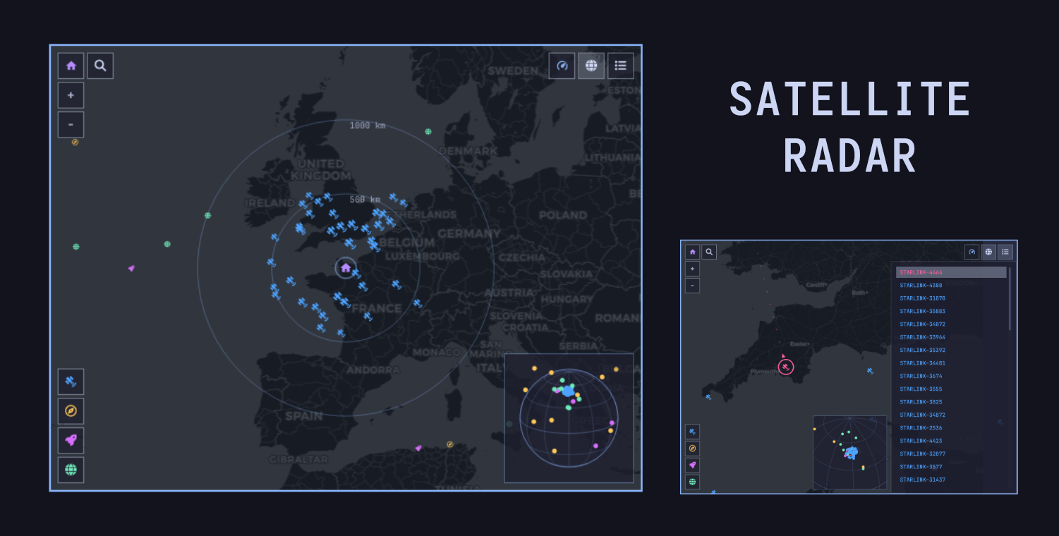
Satellite Radar preview

Features

  • Starlink, navigation satellites, space stations, and visual satellites
  • Live ground tracks, trajectories, filters, search, and satellite tracking
  • Shared location with Omarchy Weather
  • Draggable and zoomable map and mini globe
  • Balanced (60), High (150), Maximum (300), and Global modes
  • Mouse and keyboard controls
  • Visible loading and retry state when automatic location is unavailable

Install

omarchy plugin add https://github.com/SeanGSR/omarchy-satellite-radar.git --enable

Requires node, curl, and jq. satellite.js is included.

Controls

  • Drag to pan; scroll or use + / − to zoom
  • Click a satellite to track it
  • Use the toolbar for search, performance mode, globe, list, and keyboard help
  • Global mode shows the full supported catalog with Starlink hidden by default

Keyboard shortcuts:

  • ↑ / ↓ or J / K: select satellite
  • Enter / Space: track selection
  • ← / →: pan map
  • + / −: zoom
  • S or /: search
  • I: satellite list
  • G: mini globe
  • P: performance menu
  • R: refresh now
  • C or 0: recenter and zoom in on home
  • 1–4: toggle satellite categories
  • ?: keyboard help
  • Escape: close the active layer or panel

Configure

omarchy bar set ldng.satellite-radar minimumElevation 10
omarchy bar set ldng.satellite-radar performanceMode High

Network and privacy

  • CelesTrak: orbital elements
  • CARTO/OpenStreetMap: map tiles
  • Open-Meteo: city search
  • GeoJS: fallback IP-based location

TLE data is cached in ~/.cache/omarchy-satellite-radar for two hours. Failed requests back off for 15 minutes. Set a location manually to avoid the GeoJS fallback.

Positions are predictions from TLE data, not live GPS telemetry. Do not use this plugin for navigation or collision avoidance.

Remove

omarchy plugin remove ldng.satellite-radar

License

MIT. The included satellite.js license is in vendor/SATELLITE_JS_LICENSE.md.

Map data © OpenStreetMap contributors. Map tiles © CARTO.